Who Owns Scotland and the Ordnance Survey
This is an archived version of a page originally published on the website in September 2009 and is no longer an accurate account of my relationship with Ordnance Survey.
September 2009
All Ordnance Survey (OS) digital mapping was removed from this website on 23 February 2007. This was due to the unilateral termination of my contract by OS in October 2005 and my unwillingness to accept the new terms that were being proposed by them due to excessive costs, continuing contractual uncertainty and a breakdown of trust.
What follows is a very brief summary of events. The full story can be downloaded as a pdf file here and is recommended for those who wish a more detailed understanding of what happened. For information on the new mapping sources will be using, visit my mapping page [link deleted as no longer exists].
This story is being published for two reasons. Firstly, I owe an explantion to all the users and supporters of the whoownsscotland project and, secondly, this episode raises important issues about use and licensing of OS data by the citizen in the UK.
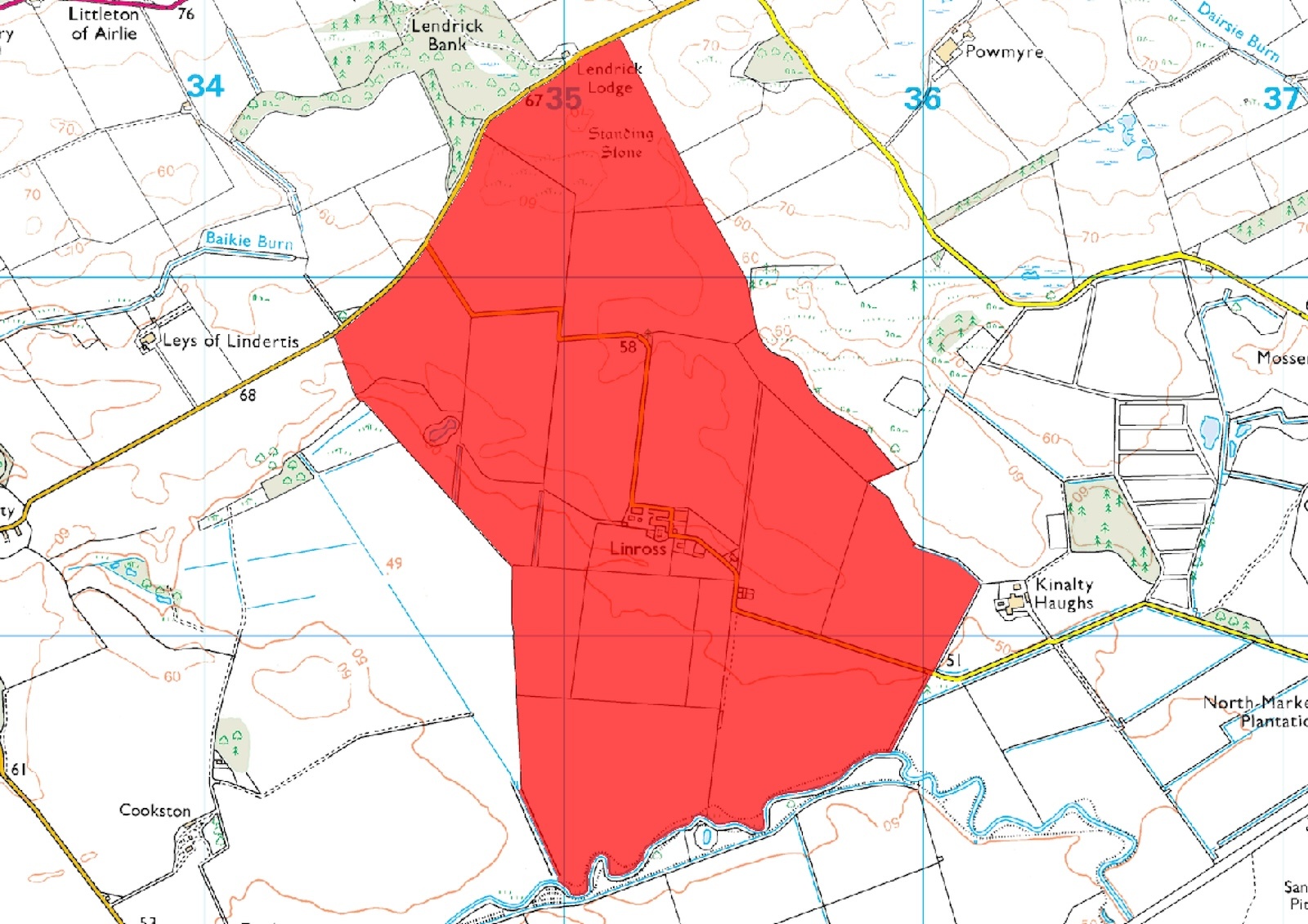
When this website was launched in May 2002, we had an agreement with the Ordnance Survey over the display of 1:50,000 and 1:250,000 scale digital mapping. This allowed us to display maps to illustrate the land owned by various landowners. The following is an example:
This arrangement worked well and no further contact was had with OS apart from annual licence renewals until I received a surprising letter from OS in October 2004 which claimed that the website was in breach of Crown Copyright.
1 October 2004
Dear Mr Wightman,
CROWN COPYRIGHT
We understand that you are the proprietor of the domain name www.whoownsscotland.org.uk and operator of the website to which that domain name resolves. It has recently come to our attention that without our authorisation or licence you are using Ordnance Survey mapping/data on the above named website...
...
...Your reproduction of Ordnance Survey mapping/data on the website without our authorisation or a licence is an infringement of Crown Copyright in accordance with the Act.
This came as something as a shock as I had purchased the original mapping data in 2002 and had paid annual licences in June 2003 and June 2004. I was a customer of OS, had by now paid them a total of £4371 and had a written agreement with them to do what I was doing. I responded immediately by phone pointing out my existing agreement and denying that I was in breach of Crown copyright. Following this telephone conversation on 5 October 2004, the OS wrote a letter to me.
5 October 2004
Dear Mr Wightman
Digital Data and Framework Direct Licence
Account No 100036507
Further to your call to our Contact Centre today, we are writing to confirm that your Framework Direct Licence (FDL) allows you to display the Scotland mapping data on your website.
...
...We would like to apologise for any inconvenience caused by the confusion over your current licensing arrangements. Please be assured that our IP & Legal Team will not need to contact you again.
I was now reassured that everything was in order and there would in future be no further questioning of what I was doing - this was premature.
In February 2005 I wrote to OS enquiring about the licensing conditions that would apply if I were to distribute the whoownsscotland website on a CD-ROM as part of the next edition of the book Who Owns Scotland. I was asked to complete a form. I did this and sent it with a covering letter dated 10 March 2005.
In late April 2005, I received a telephone call from a Mr J who said that a letter was on its way to me and that a meeting would be a good idea. I asked why and he suggested I digest the contents of the letter first. No letter arrived so I tried phoning him on 12 May but got no answer. Then a letter arrived dated 23 May 2005 followed by a phone call from Mr J announcing that he would be flying to Edinburgh from Southampton to meet me on 26 May 2005.
In this letter the OS argued that in fact the website did not conform to the licence I had and that, furthermore, the display of polygons on the OS map was potentially an infringement of Crown copyright. So now, some other part of Ordnance Survey has another look at the website and decides it does not comply with something or other. Why can't they get their act together?
Now the OS were claiming that:
...the website is not in compliance with clause 3.1 of our FDL.
Yet seven months earlier in their letter of 5 October 2004, they had said that:
We are writing to confirm your Framework Direct Licence (FDL) allows you to display the Scotland mapping data on your website.
I was confused and became increasingly alarmed at the way in which OS were apparently changing the rules every 6 months and flatly contradicting what their own legal people had been saying previously.
At the subsequent meeting, I pointed out that I had what I understood was a perfectly acceptable agreement in place which had been confirmed by OSʼs Intellectual Property and Legal Team. The OS representsative simply pointed out that from his perspective I did not have a valid OS licence. I made no headway attempting to fathom who, of all the people I have been in correspondence with, had authority to speak on behalf of the Ordnance Survey. As a customer of OS, my relationship is with OS and not a series of individuals with different stories to tell. Subsequent lengthy email correspondence confirmed that what had been agreed in the past was now being disregarded and had no force.
Protracted email correspondence followed until in July 2005 I was presented with a set of new proposed contract terms which would amount to paying anything from £10,100 - £15,700 in the first year with subsequent years costing around £5,100 and possible upwards of £10,000.
There followed a further protracted email correspondence as I tried to clarify various aspects of the revised licensing arrangements. Despite this, no firm proposal was forthcoming from OS to make a reality of what had been discussed. I decided to let things continue as they were since after all, it was not me who was proposing changing anything - it was the OS and if they wanted me to sign up to a new contract then the obligation was on them to come forward with firm proposals.
By May 2006 it was clear that I was going to be moving to Ethiopia at the end of June. My normal licensing renewal date was 31 May and an invoice was normally sent out in late May informing me of the coming years licence fee which I would normally settle in June. Since paying this would be difficult from Ethiopia I was keen to pay this but by early June I was aware that no such invoice had been sent to me. I phoned OS Customer Services to ask what had happened. They said they would find out and phoned me back the same day to inform me that all my contracts had been terminated in October 2005.
By now I was I suppose ready for anything but this took me aback once again.
The Framework Direct Licence (Section 11.1) is quite clear that:
Either party may terminate this Contractor Licence with immediate effect at any time by giving notice to the other party.
No such notice had ever been given to me.
Eventually, in January 2007, after further email correspondence, I informed OS that due to their unilateral termination of my contract, the excessive financial demands now being made and the continuing uncertainty over future licensing arrangements, I would cease using OS digital mapping and seek alternatives.
In the full version of this story, I discuss the implications of all of this and, in particular, the important issues it raises about how OS licenses its data, derived data, customer care, and a much wider issue of access to publicly-funded data in the UK.
In conclusion, I am very dissatisfied with my treatment by Ordnance Survey. I also question the legality of what they have done. But my own problems are insignificant in comparison to the wider issues this tale raises. The national topographic map belongs to Ordnance Survey (actually to the Crown) and OS license its use. However, its arrangements for doing so appear to be so hard-nosed and commercial that ordinary citizens cannot use the data that their taxes have paid for.
The only people who seem to benefit are corporations (who can afford the fees), universities (whose staff can get access) and public sector organisations. Any of the rest of us who want to do geographic research or analysis are stuffed.
When I was a boy, I grew to love maps and was fascinated by the work of the Ordnance Survey. I still love maps. I don't love the Ordnance Survey though.